 It is time for a big thank you to Ahmed and General Aviation Support Egypt (G.A.S.E) with Eddie for the incredible service we received and without which this trip would not have been possible. Being able to fly to Egypt in a private airplane shouldn't be taken for granted and requires a lot of effort and time to fight the bureaucracy. On our own, we would have never managed to get the required paperwork done and in addition to doing a superb job in securing our permissions and moving every problem out of the way, Ahmed even got us all fees waived in Port Said. We can therefore wholeheartedly recommend Ahmed and Eddie and their small venture to all pilots and are definitely going to rely on them again in the future. GA in Egypt has a bright future thanks to G.A.S.E.!
Tag Archives: Cockpit
From Sitia via Port Said to El Gouna
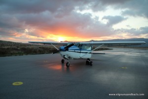 The third day and last day of our onward journey to El Gouna in Egypt. After the tempestous welcome in Stitia yesterday, the weather had calmed down today and were were able to take off as planned at dawn. Today we wanted to continue South from Crete over the open sea. Before takeoff, we ensured that our life raft and emergency equipment was well stowed and easily accessible in case of a water ditching and we put on our life vests during the whole flight. For about two and a half hours there was nothing but blue below and above us. The air traffic controllers of Greece, Cyprus and Egypt cooperated well and got us a few shortcuts to reduce the time over the open sea and save some of our precious fuel.
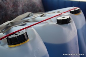
 The landing in Port Said was smooth and uneventful (not to be taken for granted with Achim piloting the airplane). However, it got more interesting after that. Right after we had turned off the engine, three strange figures approaches us. While one of them took our passports and disappeared with them, a 2 meter guy type Faceman (A-team) tried to sell us jet fuel (kerosene) which our aircraft can’t make use of — it needs something similar to car fuel. When confronted with this, he offered a discount on his fuel but unfortunately we did not reach an agreement. Then we had to go to immigration. Even though it’s called “Port Said International Airport”, there are no international flights and the immigration officer had to come in from the city center — Ahmed had arranged for this and thereby saved us at least 3 hours! In a small, dark office our passports where examined thoroughly, a visa was inserted and lots of forms filled out before they let us go back to our aircraft. We then started to syphon the fuel from our jerry cans to the aircraft’s main tanks until we were ordered to immediately stop doing this. During refueling, the fire brigade must be present and therefore we shall stop. The fire brigade then arrived with a monster truck and was waiting with the engine running while we completed our fueling. Then we got in trouble once more: our agent Ahmed told me to come with him because I had taken unauthorized pictures at the airport. A grim looking office accompanied me to a side building — as we then learned the office of the airport manager.
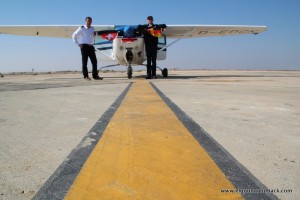 They closed the door behind me and 5 serious looking officers were standing in a row and ordered me to sit down (more explicitly when I tried to stand up). Ahmed served as translator and explained with a lot of excitement that around the airport were military installations and it was prohibited to take pictures. I had to show all pictures on my camera to the 5 uniformed officers until they started to discuss my fate in Arabic. I thought that I might end up in Egyptian prison due to espionage (Egyptians jails do have quite a reputation) but after a few minutes of discussion they sent me out again — with strict orders to not take any more pictures. Of course we complied (even though Achim was convinced he could complete the trip successfully on his own and thought that Markus could use some time for meditation and the Swiss Consulate would take appropriate care of him). Landing, securing our refueling operation and immigration were all completely free of charge — thanks to Ahmed!
Back at the airplane, Achim had completed the refueling and had our passports with the visa stamps back. We had successfully passed Egyptian immigration. With a Cessna! Not a lot of people have done this before.
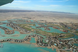 As a small thank you for his help, we took Ahmed on board and left Port Said for El Gouna (north of Hurghada on the Red Sea). A wonderful flight led us along the Med’s coastline via Cairo, the desert and then along the Red Sea’s shores to our destination. Radio coverage over the remote areas was quite bad so that we lost contact with air traffic control. Thanks to a Condor crew that relayed our position reports, we were able to stay in touch.
After two and a half hours we started our descent into El Gouna with a few orbits directly overhead the city. The landing (or should I say the 5 landings) were again gusty and rather hard — but we’ve made it! From Heubach near Stuttgart about 3800 kilometers (2000 nautical miles) in three days over the Alps and 10 countries to Egypt. Now we will spend a few days relaxing in the sun and enjoying water sports before we head back mid next week. We promise to keep you updated.
Getting ready for Africa
5:45am local time (that means 4:45am German time) is definitely way too early, in particular if you have to share a hotel room with the snoring Achim and couldn’t sleep at all. However, today we have a challenging leg ahead and need every minute we can get. While yesterday Achim managed to drop the Cessna from meters high onto the runway, today it’s about flying over the open Med for about 3 hours, going from Europe to Africa. The particular danger with a single engine airplane is that in case of an engine failure we’d have no other option than to perform a water ditching somewhere on the ocean. That’s why during the whole flight we will by wearing life jacks and have the life raft and grab bag with our survival gear readily available. Fingers crossed we won’t need any of them. Our first destination in Africa is “Port Said” (well known from TV and radio) where Ahmed is going to help us with immigration and the famous Egyptian paperwork. Also we will be siphoning the fuel that we filled into jerry cans in Dubrovnik and that has been sitting on our back bench, into the aircraft’s main tanks. We could also buy fuel in Egypt but at a price of over $5 per liter and availability at one one airport that is not on our route, we prefer our jerry can solution. If Allah agrees, we will continue onwards to our final destination El Gouna, north of Hurghada.
BTW: We’ve managed to resurrect the SPOT and hope that our live tracking feature will be back today.
Trailer
Soon in a movie theater near you
Solid impact on Crete
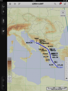 What a day! Splendid weather in Dubrovnik and everything turned out just like we had planned it. Our destination Sitia on Crete only opened at 12:30 UTC (14:30 Greek time) and only for a few hours. Nobody knows why, this is Africa… aehm no it's actually not. We didn't want to limit our options and planned our departure so that we would arrive exactly at the time of opening. We were prepared for quite a lot, having read all those horror stories by other pilots visiting Greece. Air traffic controllers that don't speak English, incompetence everywhere, less than optimal routing etc.
First we had to pass Albania and FYROM. We wouldn't want to park our aircraft in Albania but at 15 000 feet we felt quite safe. The Albanian controllers where top notch, just like at home. After that FYROM — Former Yugoslavian Republic of Macedonia — so the official name of this country. One could just say Macedonia but the Greek don't agree and like to veto in the EU because they have a little province with the same name. FYROM was a positive experience in every way: beautiful landscape and excellent air traffic control. They cared very well for us, suggesting shortcuts without being asked and asking more than once whether there's anything they can do for us.
 Then we entered Greece and the suspension rose. One thing was very positive: all controllers had a good level of English, were friendly and supportive. However, this was in no way comparable to what we had so far on this trip. Our filed routing was — like always in Europe — rather indirect and none of the Greek controllers ever thought about suggesting shortcuts to optimize our flight. When asked for it, they (as with every request) said "standby, I call you back". After what felt like 10 minutes, we got our shortcut, hoorray! We had just burned 20 liters of fuel for no reason. Then it got bizarre: "D-EDGK, direct ATV VOR, maintain heading 140". Every IFR pilot will be perplexed: one should fly directly to the beacon ATV (Athens) while pointing the nose at 140°? What if a crosswind changes our course? Should we still fly 140° or correct so that we're still flying inbound the beacon? Three attempts for clarification did not present a solution: we were supposed to fly heading 140° while going directly to the beacon ATV. Maybe they move the beacon so that it matches? We then agreed that we let her talk and continued to fly inbound ATV.
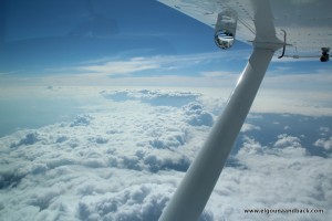
Then the weather got interesting. We knew there would be clouds with large vertical extent and that we would have to steer left and right. However, it clearly looked like a good day to fly and this was true. We were scheduled for flight level 150 (5 kilometers) and then later had to climb until flight level 180 (6 km) to stay on top of most of the clouds and not have to constantly avoid them. We are instrument pilots and allowed to penetrate any sort of cloud on this planet (besides ash clouds) but those so called towering cumulus are quite wild, giving you a roller coaster ride and shaking up the contents of the cabin. Also I didn't want to hear Markus's constant whining. At flight level 180 one has to constantly monitor blood oxygen saturation and have a good plan of what to do should the oxygen system fail. Despite years of chain smoking (Markus), our saturation was constantly between 95-98%. That's truly excellent!
 As we came closer to Sitia, we started calling the airfield to get a confirmation that it's really open. We were not successful even though we were flying very high. We started to get worried. Iraklion (our alternate) costs hundreds of Euros and does not have any fuel for us. When we asked the controllers, they told us the field is open and we shouldn't worry. Then we started to descend from 18 000 feet to 2 400 feet in rather short time and were lucky to get permission to do this as a visual maneuver so we could curve around as we pleased and avoid the nastiest clouds — by now we all know that Markus is a sissy. This was very nice of the controller as such a permission shouldn't be taken for granted thing when flying IFR.
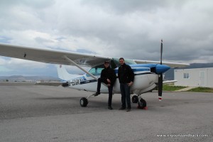 Now it was time for the approach into Sitia, VOR DME 23 for experts. The wind was horrible: 30 knots and at a 90 degree angle to the runway — it couldn't get worse! This is far beyond the airplane's certification and my experience as a pilot. We were expecting strong winds but nothing close to this and definitely not as a crosswind. Until a few years ago, Sitia had the perfect runway for this kind of wind but then they got hold of some EU funds and started building a new runway rotated by 90°. This definitely makes for interesting landings! We decided to land, given that our options were not much better with the same wind and we were convinced we would be able to do it, at least try. The landing was hard (2 jumps), I was very much afraid of the crosswind lifting one of the wings which would be disaster and therefore I used a so called crab approach (do not mix it up with the with the very frequent "crap approach") instead of the usually preferred low wing approach. In addition, I decided to perform the landing at a higher speed than normal because of the gusts and with 20° of flaps (instead of 40° as normal) to be less of a victim of the wind — especially with 120 liters of fuel in the cabin! The GoPro camera witnessed the landing. Until seeing that video, I was embarrassed by the landing and wanted to delete the video (so Markus won't be able to use it against me) but now that I've seen it I am rather proud.
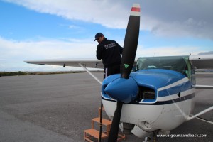 We got refueled at a bargain price of 3.20 € per liter, tied down the aircraft and entered Schengen again. The airport of Sitia is — interesting. A ramshackle hut but one could see that they were busy building a new terminal. They deserve it.
A taxi brought us to the best hotel in Stitia, at this time of the year very cheap. Very nice place here. Now we feel a strong urge for a beer and gyros, then we will make plans for Egypt.
By the way: Ahmed informed us today that he got the entry permissions for us just in time after a lot of problems. Hoorray and a million thanks to Ahmed!
Stepan Schumachović
Our taxi driver at the airport of Dubrovnik turned out to be a Croatian living in Stuttgart — what a coincidence! He’s a professional rallye driver for Audi Heidenheim and currently home and helping his father with his taxi business.
He drove as expected but very professionally (not talking about the taxi profession here). He would comment his stunts with “this would cost 1000 € fine if the Police had seen it”. Of course we had to ask him to take us back today and this ride was even better. He promised us to take us on a drive with his Volkswagen Rallye Polo (2 seats and 280 HP) when we come back to Dubrovnik in a week. What a great guy and nice acquaintance!
Day 2 preparation
Getting ready for our second leg from Dubrovnik to Sitia in Greece. Weather doesn't look that great today but we will give it a try.
Filled up our jelly cans here yesterday after arrival as getting AVGAS will become challenging from now on.
Had a great dinner in the old city center of Dubrovnik yesterday. A georgeous city we can recommend visiting. We are already looking forward to our trip back and the stopover in Dubrovnik.
Arrival in Dubrovnik
We’ve successfully completed the first leg! After an uneventful flight we landed on the deserted airport of Dubrovnik on time. Due to nothing else going on, a whole brigade took care of us. Two guys focused on filling our tanks and jerry cans and others organized the 200m drive to the terminal.
We could have performed the whole leg under visual flight rules (VFR) — at no time did we have to enter clouds.
The weather for tomorrow doesn’t look all that good but probably still good enough to continue our trip. After a great dinner in the gorgeous historical town of Dubrovnik, we went to the hotel’s splendid spa area and are now ready for bed. It’s Valentine’s day but in the bed next to me there is Markus. Isn’t that sad?
Weather — go or no go?
We've already talked a bit about it — the weather is what pilots fear more than anything else. We are allowed to fly through clouds (IFR, instrument flying) but there are limits to this, as below 0°C ice forms on our aircraft which can quickly become a major problem. We can fly below, above, beside and through the clouds, provided they don't cause icing. Before taking off, we would like to know the odds of reaching our destination as planned. It would be unfortunate if we came to realize en route that we have to turn around due to icing or make a major detour. In general, we will only take off if we know that we can land safely, i.e. there are a few inches of clear air between the cloud base and the landing strip. Our certification only requires us to have 400 meters of visibility and 200 feet (60m) between the clouds and and the runway but we don't want to get even close to such conditions — this is only for pilots that fly frequently and are well trained in such conditions.
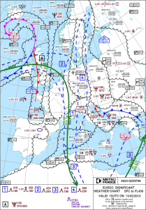 There are regular weather reports for pilots, those report actual conditions at the weather stations and therefore are very reliable. Larger aerodrome have a system which every 30 minutes determines visibility, cloud coverage, temperature, dew point, pressure, etc. The weather of the future is an entirely different animal. Meteorologists (similar to fortune tellers) specialize in asking their crystal balls (read: expensive computer models) for aviation weather which not only covers the surface weather but also conditions at higher altitudes. Everybody knows that predictions are hard, especially about the future. Some weather conditions are easy and reliable to predict, others almost impossible. Fog formation is an example of a weather phenomenon that until today, meteorologists don't grasp as it depends a lot on local conditions which are not accurately represented in the computer models. Our start aerodrome is ideally situated and only very rarely a victim of fog. Another aerodrome just a few miles away is basically covered in fog throughout the winter.
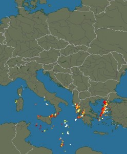 A private pilot knows a few basic things about weather. There are lows and highs. In low pressure areas, air ascends, condensates and forms clouds with rain or snow. In high pressure areas, air descends, stabilizes and we get clear skies. High is good, low is bad (incidentally, that's also Markus's attitude towards life). Even worse are fronts, those are the boundaries of air masses with different characteristics. There are cold and warm fronts. Especially cold fronts are evil as they produce thunderstorms, strong rain and reach up very high with severe icing. We definitely don't want to fly through a cold front, that's for cowboys. In the above map from the French Met Office (yes, smart pilots collect data from all over the world because instead of having one decent European Met Office, we have a zillion of mediocre national weather services doing exactly the same thing) we see the weather from today 16:00 UTC (Greenwich Mean Time or Universal Coordinate Time, used by pilots all around the world). Over Croatia, there is a cold front (blue line with teeth), moving east with 15 knots and northwest of it a small warm front (red with semi circles), moving to Italy. In the area of the cold front we expect thunderstorms, let's check this with the current lightning chart (sferics) shown above.
Indeed, there are thunderstorms (the yellow and red dots) and this is a no-go zone for us. However, the front is moving and by tomorrow it will be a Greek problem (don't they have enough already?). Let's have a look at the forecast for our destination aerodrome Dubrovnik, the Terminal Aerea Forecast (TAF):
LDDU 131125Z 1312/1412 12017KT 9999 BKN040 TX10/1412Z TN04/1405Z TEMPO 1312/1321 RA BECMG 1322/1324 04015KT BECMG 1409/1411 18007KT
A bit cryptic but in order to be able to read that, pilots attend ground school. We can see that today (Feb 13) between 12:00 UTC and 21:00 UTC there is supposed to be rain (RA). Yes, that fits to what we've seen earlier. The rain is going to stop at 22:00 and only a feeble wind (7 knots) coming from south (180°) will remain. Everything that could be bad for us like thunderstorms, rain, snow, storms would be listed here.
Now let's look at the TAF of our start aerodrome Heubach (EDTH). Unfortunately Heubach does not provide its own weather but we have the large airport of Stuttgart (EDDS) just around the corner and can use its forecast:
EDDS 131100Z 1312/1412 VRB03KT 9999 SCT040 PROB40 TEMPO 1312/1321 4000 -SN BR BKN014
Also looking good. Very little wind (3 knots) from variable directions (VRB), good visibility, scattered clouds 4000 feet above the airfield, a little bit of snow with 40% probability and some fog between 12:00 UTC and 22:00 UTC combined with low clouds. After that until the end of the forecast period on Feb 14 at 13:00 UTC only good weather. Fantastic.
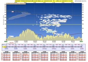 So it's looking good in A (Stuttgart) and in B (Dubrovnik), but what about the weather between A and B, that's a full 1000km? Here, we resort to a larger scale forecast model based on the Global Forecasting System (GFS), the weather model of the USA which, in contrast to the semi-capable European systems, is freely accessible (in the USA, all data produced with tax money is generally freely available, something the Europeans should take a closer look at). Here a very nice rendering of our flight profile from GFS for the planned time of flight.
This is really good. The yellow line is us at flight level 150 (15 000 feet, ca. 5km). Below you see the topography with the Alps and Dubrovnik at sea level. The dashed red line is the zero degree line which is currently at the surface in Germany and 5000 feet in Dubrovnik. In the middle you can see areas with a green shading meaning moderate icing (which in reality is quite serious with our little plane), however well below our planned altitude. There you also find clouds but they are broken, i.e. we will find our way around them. The temperature at the planned altitude is forecast between -19°C and -22°C so we hope our heater will work and we won't regret boarding the aircraft in our Egyptian beach wear.
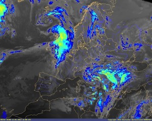
 Another interesting image is the infrared satellite photo. Using a color scale it shows the temperature of the cloud tops. Given that we have temperature data for many places on the surface and a rough idea about how air cools with altitude (the standard model assumes 2°C per 1000 feet), we can roughly estimate the top of the clouds and know which clouds we will be able fly over, fly through or (as we prefer) circumnavigate. This is a current picture, by tomorrow the nasty stuff will be gone because it's directly related to the high reaching cold front.
In summary: gorgeous weather. Markus can return his $19 Easyjet ticket that he purchased earlier. Oh, there are no refunds with Easyjet!
Electronic gadgets
Our trip requires some special equipment. On top of the survival equipment (life vests, life raft, signal flares, first-aid kit, etc.) we have to carry some technical equipment helping us with in air navigation/communication and properly documenting this adventure. In the best case, the documentation will let us keep the memories of this trip alive, in worst case it will be useful information for the aviation accident investigation authorities.
The following equipment will be carried on board:
 The primary tools for planning and performing the flight are two Apple iPads. Those devices are a perfect fit for the cockpit and are being relied upon by commercial airlines. We use them to get up to date weather information and warnings from the flight deck but also do the complete navigation with digital maps in PDF format. One iPad replaces a whole cupboard of paper documents and in case of emergency provides for a much quicker lookup of important documents than with the impractical large paper charts and binders. Also stored on the iPads are the checklists and operating instructions for emergencies (e.g. engine failure, landing gear trouble, cabin fire). We will carry two devices with identical data so that we have a backup in case an iPad packs up. Also this allows for parallel use of data: one pilot uses the map to navigate and the other checks the approach plate for the required radio frequencies (when both are playing with their iPads, George the autopilot will have to do the actual flying).
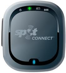
SPOT Connect is a GPS tracker with satellite communication, constantly radiating our position to the satellites (which in turn feed the live tracking page of this blog). In case of emergency, our SPOT can alert the rescue crew or send text messages of up to 45 characters to mobiles and email addresses of predefined recipients. On top of that, it can post to Twitter and Facebook and is therefore capable of everything the modern person couldn't do without for more than 30 minutes a day.
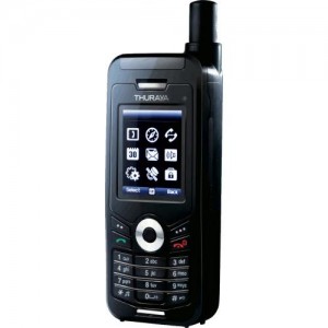 The Thuraya satellite phone allows for making phone calls in areas without mobile phone reception (e.g. in the air), send SMS and even emails. The charges when using it our outrageous so sorry mum, we're not going to call you to discuss the neighbor's cat. The Thuraya phone also acts as a wifi hotspot which lets us access the internet from our iPads in filght. This cannot be compared to your high speed flatrate at but but gives us the opportunity to send important messages, query current weather information and even make posts to this blog. It is all pretty new so there is no experience and at this point we do not know how well Thuraya will work in the cockpit.
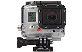 The GoPro video cameras that we are going to carry are very robust and waterproof outdoor cameras delivering fantastic wide angle recordings. They will be an important tool to document our adventure. One camera will go inside the cockpit and the other will be mounted outside on the aircraft’s hull. The GoPro app on the iPad and mobile phone provides a convenient feature to remote control the cameras so we can turn them on and off as required.
 For still images, we also carry a Canon EOS SLR camera with an all round lens. Last but not least, two laptop computers are part of our equipment so that we have a good platform to post to this blog and prepare our next legs.


